
Shopping in the Stevens Point Area
Explore local shops, from antiques to specialty shops, throughout the Stevens Point Area.
Explore local shops, from antiques to specialty shops, throughout the Stevens Point Area.

Looking for a fun adventure with kids in the Stevens Point Area? We've compiled the top educational…

Don't miss these must-see murals in the Stevens Point Area. With unique pieces tucked in every…

With a wide variety of thrift shops and consignment stores in the Stevens Point Area, you'll find…

Looking for a true Wisconsin fishing experience? The Stevens Point Area provides anglers with a wide variety of native species, including nearly…

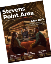
Looking for a great place to enjoy live music in the Stevens Point Area? Find some great spots, so…

It's officially 2024! To celebrate the turning of a new year, we have reviewed some of the best…

Rainy day? That's not a problem. The Stevens Point Area still has a lot to offer on a rainy…

What better way to warm up this season than next to a cozy fireplace while visiting the Stevens Point Area? Find a variety of indoor and outdoor…

Want to try the best fish fry in the Stevens Point Area? We asked, and you delivered! We set…

Taste the best beer in the Stevens Point Area with our curated guide! We asked, and you…

Diners offer a cozy, like-home atmosphere with big, hearty flavors, so it's no wonder they…

Looking for a place to stay in the Stevens Point Area with waterfront views? We've made a list of places to stay for a waterfront vacation…

Looking for a place to stay nearby the Green Circle Trail? We have compiled a guide with all…

Looking for a perfect cozy spot for a winter family getaway? Pack your bags and gather the family…

Whether you're looking to get outside or get a taste of local flavor, the Stevens Point Area is the…

Order our free Visitors Guide today to uncover the best places in the Stevens Point Area to get…
Get your free Visitors Guide and Travel Planner today!Order Guide


Looking for an electric vehicle charging station in the Stevens Point Area? We have compiled a list…

Explore local shops, from antiques to specialty shops, throughout the Stevens Point Area.

Explore the local food movement, classic Wisconsin supper clubs and everything in between to find…

Feeling artistic? Get inspired by the work of local artists, take an art class or attend a…

Explore the local food movement, classic Wisconsin supper clubs and everything in between to find…


